 |
|
 |
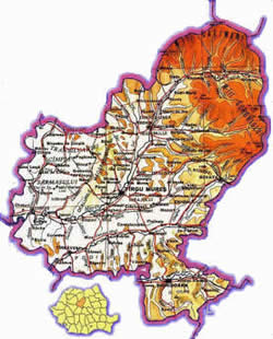
Relief:
hills and plains occupies half of the total surface, the other
half being occupied by the hills of Sub Charpatians and Gurghiu
Mountains. The basin of Mures river - with its subsidiaries
covers the total hydrographic network of the county.
Climate:
long and cold winters, and hot summers
Natural
reservations: Natural Park "Poiana Narciselor",
Dendrological Park Gurghiu, Reservation of Peonies from Zau
de Campie.
Natural
resources: existence of salt, gas, rocks used in construction,
forests used as raw materials, contribute to the growth of
economic potential of the county.
|
 |
|
|
Vegetation:
- mountain: pine, beech
- hills and plain: beech and
others species
Fauna:
brown bear, Charpatian stag, wild boor, rabbit, pheasan ,
fish, etc.
Surface:
6696 km2 out of which
- 409 000 ha agricultural field
- 219.000 ha arable
- 174 000 meadows
- 350.000 vineyards
- 6000 ha fruit farming
- 216.000 ha woods
Population:
550.000 inhabitants
50,2% living in urban and 49,8% in
rural environment
4
municipalities: Târgu Mures, Sighisoara, Reghin,
Târnaveni
7
cities: Ludus, Sovata, Iernut, Miercurea Nirajului,
Sarmasu, Singeorgiu de Padure, Ungheni
91
communes
|